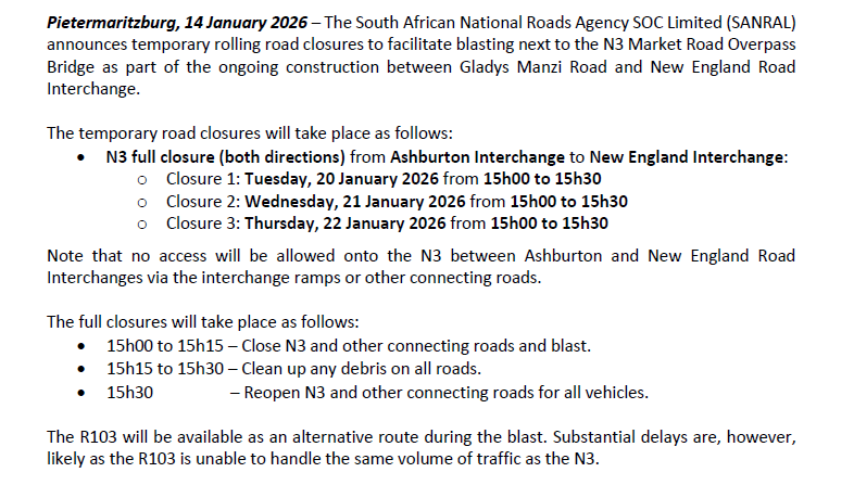
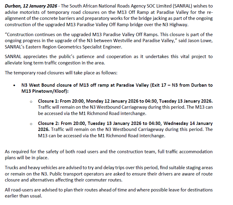
Blog

FOR BLASTING ON THE N2 BETWEEN KWABHACA AND EMAXESIBENI

TRAFFIC ADVISORY

FOR BLASTING ON THE N2 BETWEEN KWABHACA AND EMAXESIBENI

Eastern Cape, 19th January 2026: The South African National Roads Agency Limited (SANRAL) would like to notify road users that blasting is scheduled to take place on the N2 national road between KwaBhaca and EmaXesibeni on the dates indicated below. The road will be closed at 12pm for a maximum of 30 minutes.

  • On the 23rd of January 2026, the blast will take place at approximately 10,9 Km from KwaBhaca when travelling towards EmaXesibeni.
  • On the 30th of January 2026, the blast will take place at approximately 6,1 Km from KwaBhaca when travelling towards EmaXesibeni.

Motorists travelling from Kokstad towards Mthatha may consider the following alternative route:

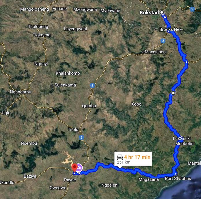
  • Exit the N2 at Kokstad and onto the R56 route towards Matatiele to Nqanarhu via Tlokoeng and then take the R396 route to Tsolo and the N2 or via Flagstaff, Lusikisiki to Port St Johns via the R61 and then re-join the N2 in Mthatha.

Similarly, motorists travelling from Mthatha towards Kokstad may consider using the same route:

  • The shortest alternative route is 69 kilometres longer and may add approximately 50 minutes to your trip between Mthatha and Kokstad.

“Motorists are asked to plan their trips, accordingly, consider alternative routes and to use caution when making use of the road,” said Kayakazi Mafuta, Acting SANRAL Eastern Cape Provincial Head.

SANRAL apologises for any inconvenience caused.


Alternative route via Flagstaff, Lusikisiki to Port St Johns via the R61 and then re-join the N2 in Mthatha.


TEMPORARY NIGHTTIME ROAD CLOSURES ON THE M13 OFF RAMP AT PARADISE VALLEY

TRAFFIC ADVISORY

TEMPORARY NIGHTTIME ROAD CLOSURES ON THE M13 OFF RAMP AT PARADISE VALLEY

Durban, 19 January 2026 – The South African National Roads Agency SOC Limited (SANRAL) wishes to advise motorists of temporary nighttime road closures on the M13 Off Ramp at Paradise Valley for asphalt paving to accommodate jacking of the existing bridge vertically as part of the ongoing construction of the upgraded M13 Paradise Valley Off Ramp bridge over the N3 Highway.

“Construction continues on the upgraded M13 Paradise Valley Off Ramps. This closure is part of the ongoing progress in the upgrade of the N3 between Westville and Paradise Valley,” said Jason Lowe, KwaZulu Natal Provincial Geometrics Specialist Engineer.

SANRAL appreciates the public’s patience and cooperation as it undertakes this vital project to alleviate long term traffic congestion in the area.

The temporary road closures will take place as follows:

  • N3 West Bound closure of M13 off ramp at Paradise Valley (Exit 17 – N3 from Durban to M13 Pinetown/Kloof):

          –Closures: Each night from 20:00 to 04:30 from Thursday, 5 February 2026 to Wednesday, 18 February 2026. Traffic will remain on the N3 Westbound carriageway during this               period. The M13 can be accessed via the M1 Richmond Road interchange.

Note that the M13 East bound onramp to the N3 (Pinetown to Durban) at Paradise Valley remains fully open.

As required for the safety of both road users and the construction team, full traffic accommodation plans are in place.

Trucks and heavy vehicles are advised to try and delay trips over this period, find suitable staging areas or reroute via the M13 or N3 to avoid major congestion. Public transport operators are asked to ensure their drivers are aware of route closures and alternatives affecting their commuter routes.

All road-users are advised to plan their routes ahead of time and where possible leave for destinations earlier than usual.


CLOSURE LOCATION:

N3 Off Ramp to the M13 at Paradise Valley (Exit 17):

  • N3 Off Ramp to the M13 fully closed at Paradise Valley (Exit 17).
  • Traffic will be diverted to continue on the N3 Westbound Carriageway and join the M13 via the M1 Richmond Road.
  • The M13 East bound onramp to the N3 (Pinetown to Durban) at Paradise Valley remains fully open.

Figure 1: M13 Off Ramp at Paradise Valley Closure (Exit 17) Detour Route

“SANRAL appeals to road users to note and comply with the advance warning signs and speed restrictions when travelling through the construction work zones. To prioritise the safety of both the construction workers and road users, the speed limit along the route will be reduced during construction”, added Lowe.


ALERT ON NATIONAL ROADS AFFECTED BY HEAVY RAINS AND FLOODING IN MPUMALANGA PROVINCE

MEDIA RELEASE

ALERT ON NATIONAL ROADS AFFECTED BY HEAVY RAINS AND FLOODING IN MPUMALANGA PROVINCE

Mpumalanga, 17 January 2026 – The South African National Roads Agency SOC Limited (SANRAL) wishes to alert road users on several national roads that have been affected by heavy rains and flooding following persistent adverse weather conditions in Ehlanzeni District, Mpumalanga province.

AFFECTED NATIONAL ROADS:

Nkomazi

Thaba Chweu

Mbombela


ROAD USERS ARE STRONGLY ADVISED TO AVOID THE FOLLOWING ROADS:

  • R582 Section 1 (between N4 and R571 over the Komatipoort River) and use N4/R571 intersection towards Mananga Border Post as an alternative route.

THE FOLLOWING ROAD SECTIONS HAVE TRAFFIC CONTROL MEASURES IN PLACE AND ROAD USERS ARE ADVISED TO EXERCISE CAUTION AND ADHERE TO WARNING SIGNS:

  • R40 Section 4 Km19 between White River and Hazyview.
  • R40 Section 4 Km 27.4 between White River and Hazyview.
  • R40 Section 5 Km 30.4 between White River and Hazyview.

THE FOLLOWING SECTION OF ROAD IS GRAVEL AND EXTREMELY SLIPPERY DURING THESE HEAVY RAINS:

  • R36 Section 3 Lydenberg to the N4 especially the first 8km from Lydenberg town.

SANRAL is closely monitoring the situation and working tirelessly to ensure the safety of all road users.

“Our Engineering teams are already carrying out assessments at the locations where it is safe to do so. Where it is still unsafe, assessments will be conducted once the flood water has subsided. Routine Road Maintenance (RRM) teams are also on standby,” said Mabuyi Mhlanga, SANRAL Mpumalanga Provincial Head.

“We appeal to all road users to reduce speed, maintain safe following distances for those roads open to traffic, and avoid driving through flooded areas, as water depth and road conditions may not be visible, “added Mhlanga.

Further updates will be communicated through SANRAL’s official communication channels as assessments continue and conditions change.

//Ends

ONGOING HEAVY RAINS RESULT IN ADDITIONAL NATIONAL ROAD CLOSURES IN LIMPOPO

MEDIA RELEASE

ONGOING HEAVY RAINS RESULT IN ADDITIONAL NATIONAL ROAD CLOSURES IN LIMPOPO

Limpopo, 15 January 2026 – The South African National Roads Agency SOC Limited (SANRAL) wishes to provide an update regarding the status of national roads in the Limpopo Province following continued heavy rainfall and flooding experienced across the province.

As of this morning, additional national roads have been affected by rising water levels and inclement weather conditions, resulting in further safety concerns for road users. In the interest of public safety, SANRAL has implemented precautionary closures on newly affected routes, while closely monitoring others that remain open but are experiencing heavy rainfall.

“Road users are strongly advised to avoid all affected areas and to use alternative routes where possible. SANRAL Routine Road Maintenance (RRM) teams remain on high alert and are conducting ongoing assessments to determine the extent of the impact on the national road network,” said Madoda Mthembu, SANRAL Limpopo Provincial Head.

AFFECTED NATIONAL ROADS:

  • National Road R527 in the Hoedspruit area within the Maruleng Local Municipality. (Alternative road is the R40 from Acornhoek through Hoedspruit towards Phalaborwa.
  • The R40 next to Maseke Game reserve is closed.
  • 25km before Phalaborwa, R71 is closed.
  • R578 section 2 Road washed away and closed
  • R71-3 (Namakgale to Phalaborwa) near the Lulekani turn-off – flooded bridge
  • R40-7 (Mica to Phalaborwa) near Grietjie – flooding across the road
  • R36-5 (The Oaks to Ofcolaco) near Ofcolaco – pooling water over the road
  • R527 – Zandspruit bridge is flooded
  • R578 (Selwana road) near Makhuva – pooling of water over the road
  • R578 at about km5.4 section 2, bridge washed away and road is closed.
  • R578 at about km 20 section 2 is closed
  • Greater Letaba bridge from R529 to Eiland road. Water level close to flooding the bridge

ROADS OPEN TO TRAFFIC BUT EXPERIENCING HEAVY RAINS:

  • National Road R81 in the Giyani town
  • R33 between Groblersdal and Stofberg
  • R526 section 2, km 12.4 from Gravellotte heading towards Hoedspruit

“Road users travelling on routes affected by persistent rainfall are urged to exercise extreme caution, reduce speed and maintain safe following distances on roads that are open to traffic. Further communication will be issued as assessments continue and once it is confirmed that conditions are safe for the re-opening of affected national roads,” added Madoda Mthembu.

SANRAL encourages road users to refrain from travel until the roads are open and safe for use.

//Ends

N3 FULL CLOSURE TO FACILITATE BLASTING ACTIVITIES BETWEEN NEW ENGLAND INTERCHANGE AND MARKET ROAD INTERCHANGE

TRAFFIC ADVISORY

N3 FULL CLOSURE TO FACILITATE BLASTING ACTIVITIES BETWEEN NEW ENGLAND INTERCHANGE AND MARKET ROAD INTERCHANG


The closure may need to be adjusted depending on weather conditions on the day. If that happens, a second notice with information about the new time will be issued.
“Our traffic accommodation team, with the assistance of the Road Traffic Inspectorate (RTI), have carefully planned the closures and will manage and monitor them for their full duration” said Jason Lowe, SANRAL’s KwaZulu Natal Specialist Geometrics Engineer.
“We understand that these road closures cause major disruption and have planned them to take place at times when the disruption is minimised. Trucks and heavy vehicles are advised to try and delay trips over this period or find suitable staging areas to avoid major congestion. Public transport operators are asked to ensure their drivers are aware of route closures and alternatives affecting their commuter routes. Light vehicle traffic, as well as emergency services and traffic management are advised to make use of alternative routing. SANRAL apologises for any inconvenience caused and appreciates the public’s patience during the ongoing major road enhancements.” said Lowe.

TEMPORARY CLOSURE OF NATIONAL ROADS IN LIMPOPO DUE TO FLOODING

MEDIA RELEASE

TEMPORARY CLOSURE OF NATIONAL ROADS IN LIMPOPO DUE TO FLOODING

Limpopo, 14 January 2026 – The South African National Roads Agency SOC Limited (SANRAL) wishes to inform road users of the temporary closure of certain national roads in the Limpopo province that have been severely affected by flooding as a result of adverse weather conditions experienced across the province.

The incessant rainfall has led to rising water levels, leading to unsafe driving conditions in affected areas. In the interest of road user safety, SANRAL has implemented precautionary closures on the affected routes until further notice.

AFFECTED NATIONAL ROADS CURRENTY CLOSED TO TRAFFIC

  • National Road R527 in the Hoedspruit area within the Maruleng Local Municipality. (Alternative road is the R40 from Acornhoek through Hoedspruit towards Phalaborwa.
  • National Road R578 from south of Phalaborwa towards Giyani. (alternative road is the R71 towards Tzaneen and take R36 & R81 to Giyani).

ROADS STILL OPEN TO TRAFFIC BUT EXPERIENCING HEAVY RAINS:

  • National Road R81 in the Giyani town
  • R36 between Groblersdal and Stofberg
  • R555 between Stofberg and Rosenekal

“We strongly advise road users to avoid the affected roads and make use of alternative routes where possible. Further communication will be issued once detailed assessments have been done, and the affected national roads are safe to be re-opened to traffic,” said Madoda Mthembu, SANRAL Limpopo Provincial Head.

SANRAL appeals to all road users to prioritise safety and remain informed through official communication channels.

//Ends

TEMPORARY LANE CLOSURES ON N2 UMHLANGA RIVER BRIDGE TO FACILIATE BRIDGE DECK WIDENING

TRAFFIC ADVISORY

TEMPORARY LANE CLOSURES ON N2 UMHLANGA RIVER BRIDGE TO FACILIATE BRIDGE DECK WIDENING

Durban, 13 January 2026 – The South African National Roads Agency SOC Limited (SANRAL) advises motorists of the upcoming temporary fast lane closures on the Umhlanga River Bridge. The closures are required to complete the works for widening of the bridge deck.

“The N2 upgrade project between the KwaMashu Interchange and the uMdloti Interchange is progressing well. Once complete the N2’s capacity will be significantly improved to a total of 5 lanes in either direction between the KwaMashu and Mount Edgecombe Interchanges and 4 lanes in either direction thereafter to the uMdloti Interchange,” said Jason Lowe, SANRAL’s KwaZulu Natal Specialist Geometrics Engineer.

The temporary road closures will take place as follows:

  • N2 fast lane closure (both directions) at the Umhlanga River Bridge from 19:00 on Friday, 16 January 2026 to 04:00 on Monday, 19 January 2026

“While one lane per direction will still be open to traffic the speed limit will be reduced to 40km/h. This is required to ensure that vibrations within the bridge, caused by traffic, are kept to a minimum so that freshly poured concrete is given enough time to gain strength to resist the normally expected vibrations,” said Lowe.

Heavy delays are expected on the N2 unless trips are delayed or re-routed. Trucks and heavy vehicles are advised to try and delay trips over this period and/or find suitable staging areas. Public transport operators are urged to ensure their drivers are aware of the anticipated congestion and consider alternative routes. The alternative routes available are the M4 and the R102.


Ends//

TEMPORARY ROAD CLOSURES ON M13 OFF RAMP AT PARADISE VALLEY FOR PREPARATION OF OVERPASS BRIDGE JACKING

RE-ISSUE TRAFFIC ADVISORY

TEMPORARY ROAD CLOSURES ON M13 OFF RAMP AT PARADISE VALLEY FOR PREPARATION OF OVERPASS BRIDGE JACKING


CLOSURE LOCATIONS:

Closures 1 and 2: N3 West Bound closure of M13 off ramp at Paradise Valley (Exit 17 – N3 from Durban to M13 Pinetown/Kloof):

  • M13 Off Ramp at Paradise Valley (Exit 17) fully closed.
  • Traffic will continue on the N3 Westbound Carriageway and may join the M13 via the M1 Richmond Road interchange.

Figure 1: N3 to M13 Off Ramp Closure at Paradise Valley (Exit 17) – Detour Routes

“SANRAL appeals to road users to note and comply with the advance warning signs and speed restrictions when travelling through the construction work zones. To prioritise the safety of both the construction workers and road users, the speed limit along the route will be reduced during construction”, added Lowe.


SHOULDER CLOSURE ON THE R61 SECTION 6 FROM ALL SAINTS TO BAZIYA

TRAFFIC ADVISORY

SHOULDER CLOSURE ON THE R61 SECTION 6 FROM ALL SAINTS TO BAZIYA

Eastern Cape, 19th December 2025 – The South African National Roads Agency SOC Limited (SANRAL) advises road users that a shoulder closure and reduced speed limit will be implemented on the R61 Section 6 between All Saints (km 68.50) and Baziya (km 78.60), where construction activities are underway.

During the shutdown period from 12 December 2025 to 7 January 2026, shoulder closures will be in place from km 68.50 to km 69.60 for road widening works, and from km 73.60 to km 78.60 for permanent works along the R61.

Motorists can expect a delay of about 10 minutes or less and the required reduction in traveling speed will be posted along the closure to ensure everyone’s safety.

“Motorists are asked to plan their trips, accordingly, to reduce speed when approaching the construction zone and to use caution when making use of the road,” said Mbulelo Peterson, SANRAL Eastern Cape Provincial Head.

SANRAL apologises for any inconvenience caused.

EMERGENCY BRIDGE REPAIR WORKS (REPAIR OF BRIDGES ALONG THE N2 SECTION 16 MDANTSANE TO THE GREAT KEI RIVER)

TRAFFIC ADVISORY

CONTRACT SANRAL X.003-022-2019/1-C6
EMERGENCY BRIDGE REPAIR WORKS (REPAIR OF BRIDGES ALONG THE N2 SECTION 16 MDANTSANE TO THE GREAT KEI RIVER)

Traffic advisory for period 11 December 2025 to 07 January 2026

Eastern Cape 17th December 2025: The South African National Roads Agency SOC Limited (SANRAL) would like to notify road users that the N2 National Road between Mdantsane (Section 16 Km 0,0) and the Great Kei River (Section 16 Km 80,22) will be open to traffic in both directions. No stop / go or lane restrictions will be in operation on this road section. However, road users should be vigilant and adhere to the maximum speed limit as per the road signs.

“Motorists are asked to plan their trips, accordingly, and to use caution when making use of the road,” said Mbulelo Peterson, SANRAL Eastern Cape Provincial Head.

SANRAL apologises for any inconvenience caused.