Mtentu North: tagging forest trees
SANRAL adheres to strict environmental regulations and complies with the Record of Decision (ROD) during the N2WCR project.
Before geotagging plants and trees, the relevant permits had been issued for the destruction and search and rescue of plants in this area.
A total of 172 trees of 13 species with a diameter of 30cm or more, 1m from ground level, were identified and geotagged during an environmental survey of the Mtentu North forest area of the N2 Wild Coast Road project. Five of the 172 trees were unidentified species.
Specially made metal tags were used during the survey to mark these identified and geotagged trees.
All tags have series numbers punched individually which correspond to the recorded GPS coordinates for each tree. During the tagging process, GPS cameras were used to geotag and record the location of each tree and document the tracks followed during the survey.
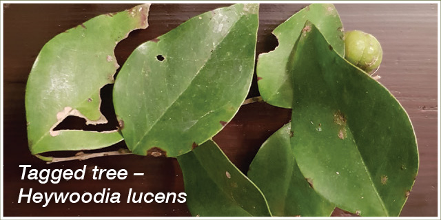
The identification numbered tags were all nailed into the trees.
The nail was spray painted with yellow paint for better visibility. The tree species, size, tag number and circumference were documented on the plant list spreadsheet. Where possible, samples of leaves, fruit and flowers were taken for identification.
The identification and documentation of other forest plant species, plants growing between the forest canopy and the forest floor, also formed part of the survey.
All threatened and protected forest species were identified, documented and geotagged.
A total number of 105 plant species were identified and documented in the forest and forest edge. The plant types identified and documented included 51 trees, 22 shrubs, 19 groundcovers, 6 ferns, 8 climbers, 3 orchids and 2 grasses.Photographs were taken of species, where possible, for record purposes.
SANRAL works with other environmental and government stakeholders to ensure there is minimum disturbance to the environment during construction work.

Plant fossils found
Large Lycopod stems were found near Port St Johns, indicating that more can be expected in the excavations for the N2WCR project, according to the Phase 2 Palaeontological Assessment Progress Report of September 2018.
The report seeks to confirm the existence of exposed, and potentially palaeontological heritage, vegetation on the site of the proposed development, assess the impact the development may have on this resource and recommend measures to mitigate the impact.
To date, poorly defined trace fossils and imprints of plant fossils were observed during the field investigation. The potential for finding significant fossils in any excavation into sediments of the Msikaba Formation is theoretically low, but
when exposed during blasting, improves to very high, with potential to find fossils in the formation rated as very high.
Along the Mtentu Bridge site, high energy beach deposits with clearly defined “herringbone” cross-bedding that indicates tidal action during deposition of the sandbars, were discovered. The present allocation of a low palaeontological significance is likely to change as construction progresses.
Dr Gideon Groenewald, an independent specialist consultant, provided palaeontology training for the construction team on the identification of fossils and steps to follow should fossils be discovered on site. Training was held on 16 May.